The East Sussex Light Railway
 Following the opening of the Rother Valley Railway between Robertsbridge and Tenterden, the company lost little time in planning several extensions. Lines to Pevensey, Rye, Appledore and Cranbrook were all authorised within a year of the opening. None came to pass, except a short section of the Cranbrook line that formed the extension from the original Tenterden terminus (now Rolvenden) to Tenterden Town station completed in 1904.
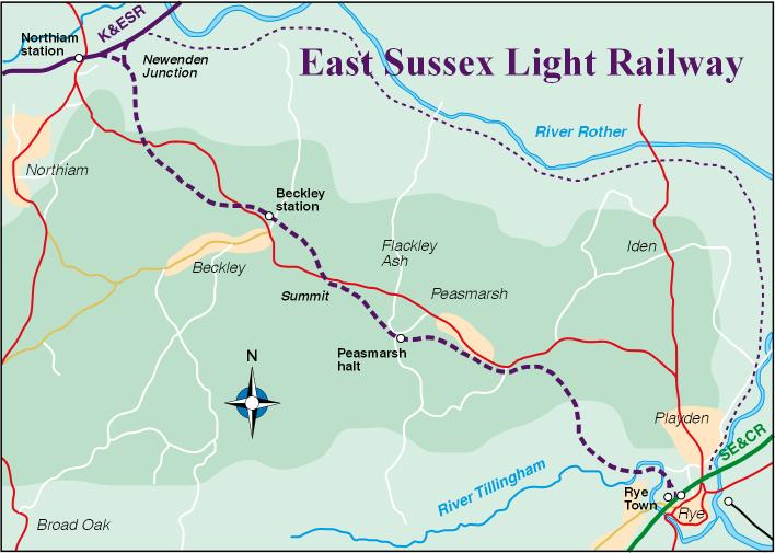
Promoted as the East Sussex Light Railway, with Colonel Stephens in charge, the Rye branch would have run from Northiam on the original RVR route. Most maps, including those which appeared in K&ESR annual reports until 1934, show the line following the River Rother to enter Rye from the northeast.
Visiting the East Sussex County Records Office in Lewes to consult the original plans and sections, Stephen Hannington found that the proposed route was very different.
Rather than following the Rother flood plain, Stephens proposed a route that diverged from the RVR with a triangular junction just east of Northiam station and climbed steeply into the higher ground to the south-west, paralleling the present A268 and passing close to Beckley and Peasmarsh before descending into the valley of the River Tillingham. This would have given an easier approach to Rye compared to the narrow shelf between Rye Hill and the Rother, which was already well developed by the end of the 19th century.
The projected route would have involved several stiff 1 in 50 gradients to reach a summit at 144 feet above sea level, just east of Beckley and 3½ miles from Northiam. Earthworks would have included a 23 ft deep cutting and a 17 ft high embankment. Beyond the summit, the line would have descended again at 1 in 50 through the delightfully-named Secret Wood below Peasmarsh before crossing the Tillingham twice on bridges of 50 ft span. The branch would have been around 6 ½ miles long, as against 9 miles following the Rother.
Rather than running into the South Eastern Railway station at Rye, the line would have had its own terminus close to Ferry Road level crossing. A sharply-curved link of 6 chains radius was envisaged for the exchange of goods wagons, but there were suggestions that the SE&CR was reluctant to permit a connection. The promoters were still keen enough to apply for an extension of powers in 1904, but no work appears to have taken place after that time.
Adapted from an article by Stephen Hannington
in The Colonel issue 61, Winter 2000
Copyright ©Chris Jackson
Contact ryetown@landia.me.uk